
More information
This site intends to show the public, journalists and politicians Marine Protected Area management and governance in places set up to protect our important wildlife hotspots. We have promoted it to national and international practitioners. Whilst there was progress within the 10 English IFCAs to get regulations in coastal seas due to exclusive competency since 2013, offshore regulations weren’t in place to manage fishing in offshore sites (outside 12nm) before 2021 due to the need to undertake joint recommendations with 3rd party EU Member States, endorsed by the European Commission. EU Exit has allowed the UK to protect offshore MPAs since this time, leading to multiple regulations.
As of the end of September 2025, 65,629km2 (27.97% of the total 234,625km2) of the English seabed is within an MPA. 26,797km2 (11.4% of the total sea area) is within a restriction that permanently protected from all types of bottom towed fishing gears, this is mostly within MPA boundaries, though 4,751km2 falls outside.
A further 30,000km2 is being proposed (summer 2025) for protection from bottom towed fishing gears in 41 offshore sites. If this additional area were to be protected, the percentage cover of English seas included in a byelaw protecting the seabed from bottom towed fishing gear would rise to 24.2%.
220,953km2 (35.8% of the total 617,530km2) of Scotland’s seas are designated for protection of seabed features in MPAs and 205,937km2 (33.3%) is protected from all forms of bottom towed fishing gears. Approximately 150,000km2 was already automatically protected from these fishing gears within offshore MPA waters as MPA areas over 800m deep are protected by an historic ban on trawling below this depth for ALL Europe’s seas to safeguard deep sea habitats. An additional tranche of byelaws came into law on October 16th 2025, adding to the area protected from bottom towed fishing gears (note that 8 of these are not included on the Reality Check as they allow demersal seining or other forms of mobile bottom contact fishing).
While 31,334km2 of Scottish inshore waters have been designated as MPAs (34.7% of the total 90,422km2), only 3,495km2 (3.9%) is protected from bottom towed fishing gears. So far, only highly vulnerable sites have been protected from scallop dredgers and (predominantly) nephrops beam trawlers. Academics have calculated that this only equates to stopping dredging and trawling in about 1% of the area that they have historically used.
In Wales, the figure of total protection from all forms of bottom towed fishing is 13km2 (0.04% Welsh waters) that is at Skomer Island – the only place where all forms of bottom trawling and scallop dredging are restricted. Wales has stopped scallop dredging for king scallops (Pecten maximus) from all its SACs apart from an outer area of Cardigan Bay. This law was passed in 2010. However, Welsh Government hasn’t followed this up with any restrictions on otter trawling or beam trawling by Welsh or other vessels. Wales waters cover 30,778 km2.
38% of Northern Ireland’s inshore seas are in MPAs designed to protect the seabed. In January 2023, an order came into force prohibiting bottom towed fishing gears in all or parts of nine inshore SACs and MCZs designated to protect the seabed (The Marine Protected Areas (Prohibited Methods of Fishing) Regulations (Northern Ireland) 2022). The largest sites are at the Skerries, Rathlin Island and Strangford Lough. Coverage of measures to protect vulnerable seabed habitats to bottom trawling is approximately 6,819km2.
A brief guide to MPA management in England
MPA – Marine Protected Area. A ‘catch-all’ term for all types of designation.
MPA Reality Check predominantly maps UK bottom towed fishing gear restrictions and Highly Protected Marine Areas (where all fishing and damaging activity is prohibited).
Currently the UK has retained European Marine Sites since leaving the European Union on 1st Jan 2021 (after which the terms of the ‘Trade and Cooperation Agreement’ came into force). The UK transferred all existing legislation to protect such sites from activities into UK law at that time.
As of Jan 1st 2021, the EU Exit 'trade and cooperation' agreement came into force that now allows UK to unilaterally protect its offshore MPAs, as long as there is no discrimination between measures applied to protection that equally restrict both UK and EU fleets. In June 2022, the first four offshore MPA management measures to prohibit bottom towed fishing gears came into force. These protected the English Dogger Bank SAC (at over 12,300km2, the largest offshore MPA in English waters), the Inner Dousing and Race Bank SAC (with partial closures to protect the extent of sandbank and reef features), South Dorset and The Canyons MCZs (the latter with partial closures to protect site features). A further 13 offshore English MPAs reef area habitats were protected from bottom towed gears in summer 2023.
European environmental law requires Member State Governments to set up protected areas to ensure the protection of biodiversity both on land and in the sea. These sites are called Special Areas of Conservation or SACs for flora and fauna and Special Protection Areas (SPAs) for birds. Collectively these are known as 'European Marine Sites', collectively making up a network of ‘Natura 2000’ marine sites. Government conservation bodies such as Natural England & JNCC carry out surveys, and in consultation with stakeholders determine where these habitats and species are and identify appropriate boundaries for MPAs. These sites remain as designated sites in UK waters after Brexit (under the UK ‘Habitats Regulations’).
SACs are not designated to protect areas as such, but to protect specific features within those areas (such as seagrass bed or pink sea fans). Designation orders for each site name the features which are formally protected, Conservation Objectives for the areas state whether features need to be 'restored to' or 'maintained at' to ‘favourable conservation’ status. General Management Approaches state whether features need to be 'restored' or 'maintained' to achieve ‘favourable conservation’ status.
Once a site has been designated, the law requires that the designated features within a site reach, or are maintained at favourable conservation status. In order to do this, human activities that are, or are likely to have an impact on them need to be managed in some way. The management of sites places specific obligations on different agencies to ensure that appropriate and 'proportionate' measures are put in place. The process has been set out within the Directives and established within National Regulations on how this is carried out.
English Government has two statutory conservation advisors: Natural England (NE) and the Joint Nature Conservation Committee (JNCC). In the marine environment it is Natural England that provides conservation advice for sites that are within territorial waters (up to 12 nautical miles) and the JNCC who provide advice for offshore sites outside of territorial waters. Often their advice is aligned, particularly where MPAs straddle this boundary.
The conservation advice is used by Relevant Authorities to understand the ecological requirements of the site and provide a clear indication of which human operations might cause species and habitats to be disturbed or damaged (see the designated sites system (DSS) of NE). In the marine environment, Relevant Authorities are bodies such as Harbour Authorities, Local Authorities, Water companies or the Environment Agency and Inshore Fisheries and Conservation Authorities or the Marine Management Organisation (MMO) that have local powers and functions that take this advice and act on it. They have a fundamental bearing on how the marine environment is protected based on their understanding of local socio-economic needs and their local understanding of conservation advice, and the law.
The process through which the need for management is assessed for SACs and SPAs is known as an 'Appropriate Assessment' for any new project within or adjacent to a site that may affect its conservation status. This assessment has a very strong level of precautionary protection built into its rules. Such an assessment would normally be carried out by a consultant on behalf of a developer who wanted to undertake a plan or project in (or near) an SAC or SPA. This process considers the likely impact of the plan or project on the ecological integrity of the site, its protected features and typical species. The decision on whether to license an activity ultimately rests with the MMO (Marine Management Organisation) for recreational and major infrastructural developments. The MMO also manages fisheries in offshore MPAs beyond 6nm with advice from Natural England (up to 12nm) and JNCC (beyond 12nm) on likely significant effects of fishing gears.
Fishing Activity is being handled through a separate process due to its more widespread nature and high variance of gear types and activities. Fishing activities have been ranked according to their potential impact to features, and the 10 English inshore IFCAs (Inshore Fisheries and Conservation Authorities) and the MMO have been tasked with ensuring that where features could be damaged from fishing gear, then byelaws are introduced to restrict activities. This is an ongoing process to ensure that features in new MPAs will be managed if they are likely to be sensitive to fishing activities. Such assessments are made through ‘risk matrices’ of likely threat from individual fishing activities on individual MPA features. MCZs, which were designated in three tranches (2013, 2016 and 2019) subsequent to SACs and SPAs, are subject to a similar analysis of risk and threat from fishing, and are therefore subsumed into the same regional and local risk matrices by IFCAs.
Estuaries such as the Fal and Helford, Tamar, Solent, Humber and Severn, where there is a wide variety and high intensity of human activities, have management schemes which allow Relevant Authorities to operate collaboratively. These groups determine activities that may incur risk of damaging sites – be they ongoing activities, new plans or projects, and indeed so-called ‘in combination’ effects whereby different activities combine to make a significant impact.
Surveys to determine the status of a feature need to take place as part of a regular reporting process for European Marine Sites. Such 'condition assessments' provide conservation advisors with the information they need to determine if management is effective. Yet the funding and science to make these assessments is significantly lacking to effectively manage our expansive MPA network, and gauge impact. As such, conservation advisors most often use ‘expert judgment’ based on peer-reviewed science of similar interactions elsewhere, and/or scale up their assessments based on small-scale monitoring projects. This is not ideal, but a reasonable approach to managing our large MPA network given resource constraints.
Effective management at sea
On land, it is normal to carry out conservation by managing land in a more active sense, for example by creating ponds and hedgerows. It is also possible to map and assess the health and extent of species and habitats relatively easily and robustly using ecological observation, transects & camera traps by individual observers using relatively simple equipment. At sea, this is much more difficult since we don’t have the resources or technology to do this at large scales. Active intervention to artificially ‘create’ marine habitats is expensive, and can only be undertaken in relatively shallow waters at present (e.g. saltmarsh, seagrass, dune habitats). In most instances and areas of MPAs we need to rely on habitats being protected from damaging human activities to recover themselves – at nature’s pace - once the damage is stopped. The speed and nature of this recovery is inherently uncertain, as indeed is the course of recovery itself.
As such – compared to terrestrial examples, the use of the precautionary principle is particularly relevant to managing the marine environment; it essentially means that where you are not sure about what is the result of individual or combinations of human activities on the environment, it is best to err on the side of protection and restriction. For most habitats and species that live in the sea for which we have designated MPAs, it is very difficult to determine their condition and if they are getting 'better' or 'worse' in their target of achieving 'favourable conservation status'. It is often difficult to separate natural variation in habitat condition and natural disturbance with impacts caused by humans. We often need to rely on general indicators and published science in order to extrapolate and model our knowledge from one site across others.
The use of expert advice and precaution has an important role to play in identifying when a feature is likely to be sensitive to certain fishing gears. Ultimately, we need to ensure that MPAs are being effective in their job of protecting our marine habitats and species from harm caused by humans. Over time, we will gain a greater knowledge of how different marine species and habitats are impacted and how they recover. This is particularly the case where we have science being undertaken on some of the relationships in the ‘risk matrix’ discussed above. Predominant within this effort has been to understand the relationship between bottom towed fishing gears and seabed habitats from reefs, to cobble reefs, to rich sandy sediments. Studies on the impacts of port and aggregate dredging, the impacts of upstream water quality, and recreational activities have been useful for assessing plans and projects in sites. The offshore sea area is also benefitting from science undertaken within our developing and expanding offshore wind industry.
Marine Conservation Zones
Similar evidence considerations enabling protection measures for SACs and SPAs are facilitated by the designation of Marine Conservation Zones under domestic legislation (The Marine and Coastal Access (2009) Act). Legislation supporting these areas confers duties on statutory authorities to further the conservation objectives of site features for which sites are designated.
91 MCZs have been designated around England in three tranches (27 in 2013; 23 in 2016; and 41 in 2019). Management measures have been established by IFCAs for 98 inshore MCZs, SACs and SPAs, and the MMO for offshore sites (ongoing). Some existing measures (such as set-net bans in estuaries) also cover many of the needs to protect the seabed and associated species and ecosystems (e.g. for ‘fish’ as typical species of estuarine habitats).
Byelaw implementation to prevent bottom trawling and scallop dredging has been slow up to 2019 relative to the size and impact of the fishery, and its increasing intensity since the 1980’s – particularly for non-quota scallops. This is not least because of the 'feature-based approach' to management whereby regulators (with advice from Natural England) need to justify conservation measures to protect individual features within sites, and assess condition. If condition is considered to be good, then activities can usually continue. In 2018 the UK Government considered a ‘whole site approach’ to managing UK MPAs that would necessarily include stronger and more spatially comprehensive management. Science underpinning this approach across a variety of habitats for many attached and mobile species is continuing to inform the benefit of such an approach. The Marine Conservation Society has inputted to this initiative with collaborators from academia. A consortia of fisheries managers, lawyers, academics and campaigners published a paper in 2020 to illustrate a collective will to deliver more effective MPAs, that includes adoption of a whole-site approach to management for as many sites as possible.
For sites that currently aren’t perceived as being heavily fished, regulators are disinclined to introduce regulation (e.g. North Cornish coast; Essex coastal waters; Beam and otter trawling in Welsh MPAs). It is often the case that information on assessment of site condition are made is by word of mouth & personal knowledge, rather than from scientifically collected data (using adequate ‘controls’). For example, the North Cornish tranche 2 MCZ of Hartland Point to Tintagel is unlikely to get an IFCA byelaw to restrict bottom trawling largely because the rocky nature of the seabed coupled with strong tidal conditions are considered likely to restrict such fishing. By contrast, the MMO in the small offshore part of the site is currently (summer 2025) considering a byelaw to restrict bottom trawling at this marginal offshore section of the MCZ. Similarly, the partial management of Essex estuaries by Kent and Essex IFCA is justified because of a lack of seabed data, and limited fishing boat observation in the site, rather than clear scientific understanding of the impact of infrequent trawling activity in this part of the site. Northumberland IFCA aren’t regulating bottom trawling for light otter trawls in the Coquet to St Mary’s MCZ. Decisions not to regulate in these areas of MPAs are based on word-of-mouth and enforcement patrol observations. A report on a stocktake of the provenance and results of these interventions was published by the Blue Marine Foundation in summer 2025.
Whilst offshore fishing is monitored on a 2-hour basis using satellite Vessel Monitoring Scheme (VMS) throughout the EU and UK, nearshore smaller coastal fishing boats have just had inshore VMS set up. Such technologies enable regulators to set up ‘geo-fences’ around MPA boundaries. Entry of vessels into a zone close to restricted areas inside MPAs can then stimulate messages sent directly to vessels to turn around, or increase speed (to ensure that fishing gear cannot operate).
The Marine Management Organisation is tasked with delivering management for our offshore MPAs (between 6nm to 200nm), predominantly of fishing activities in English waters. It receives nature conservation advice from Natural England (up to 12nm) and JNCC (beyond 12nm).
When we were part of the EU, offshore management measures were introduced under consultation and mediation with other member states with fishing interests in UK sites. This has led to very slow processes of introducing weak management. From 2016 to 2018 the UK submitted a number of management recommendations for offshore English MCZs and SACs for consultation with other member states. The Scottish Government submitted proposed fisheries management measures for MPAs and SACs in the offshore zone adjacent to Scotland in 2017.
In summer 2019, environmental charities across Europe challenged (via a formal complaint) the effectiveness and legality of proposed management measures for the large Dogger Bank offshore Special Area of Conservation that sits astride UK, Netherlands and German Exclusive Economic Zones (EEZs). Some argue that the only way to achieve consensus on managing fishing activities in offshore MPAs with neighbouring member states is to have such weak measures, that integrity of the MPAs is compromised whilst profitable fishing activity persists. A report released in October 2020 to both the UK and EU by a group of NGOs provided the legal and ecological evidence required to support bottom towed fishing in the site. A further report released in 2021 on the eve of EU Exit showed the prevalence of ongoing bottom trawling over UK offshore MPAs that were then in the gift of the UK (since the Trade and Cooperation Agreement) to regulate using unilateral non-discriminatory fisheries byelaws.
The UK Government launched a consultation on management measures for 4 offshore MPAs in English waters – 2 MCZs, and 2 SACs in February 2021. This includes a potential to close the entire Dogger Bank to all forms of mobile bottom contact fishing gear. This would increase the area of the UK protected by such a measure by over 12,300km2.
In 2022, the UK Government introduced management measures for 4 offshore MPAs in English waters – 2 MCZs, and 2 SACs. In July 2023, a further 13 offshore MPAs (SACs and MCZs) had reef areas protected from bottom trawling and dredging. In addition to these area-based management measures, the UK and Scottish Governments also decided to remove targeted sandeel fishing from the English North Sea and all Scottish seas in order to support stronger food webs, enhancing the ecosystem including populations of mid-water fish, sharks, rays, cetaceans and seabirds. This measure was to meet legal commitments to the UK Marine Strategy Framework regulations.
English Government has a planned timetable to undertake protection measures for all offshore MPAs by the end of 2024.
In July 2023, three Highly Protected Marine Areas (HPMAs) were designated in England with the aim to allow the full recovery of marine ecosystems – Allonby Bay (inshore, off Cumbria), Dolphin Head (offshore in the English Channel) and North East of Farnes Deep (offshore in the North Sea).
As of summer 2025, 41 offshore SACs and MCZs are being consulted on for protection of seabed habitats from bottom towed fishing gears. This could increase the area of seabed protected from bottom towed fishing gears inside UK offshore MPAs by an additional 30,000km2, raising the % area of seabed protected from all forms of bottom towed fishing in English offshore waters from 11% to 24%. Measures to protect sensitive habitats from anchored nets and lines (2 MPAs) and pots (5 MPAs) are also being considered.
Scotland announced measures to protect offshore MPAs in October 2025 having established its network of MPA locations in 2015. There still remain many nearshore MPAs that are yet to receive fisheries management measures since the initial tranche of inshore MPA protections in 2016. These areas are scallop dredged, prawn trawled and creel fished by coastal fleets.
The 10 English IFCAs (inshore fisheries and conservation authorities) have emerged from the old ‘Sea Fisheries Committees’ that were in place up until 2009. Since 2009, IFCAs have had a role in managing the inshore seas, and are part funded by local authorities and Defra. They have committees that are made up of councillors (representing local communities and the funding from local government), fishers and conservationists. Day to day work by the staff of each IFCA reports to these committees, but decision-making power lies within the committees that are advised by IFCA staff. They vote on new and updated regulations for the management of Marine Protected Areas and to set sustainable fishing limits in their districts. The MMO ‘balances’ the committee membership by recruiting from conservation and industry such that a range of views is given and represented.
Full time work by IFCA staff involves scientific research, regulation, surveillance and enforcement of vessels in their district. They have also been given the job of trying to manage and control the activities of the recreational angling sector – bait digging is a particularly difficult issue to manage, and is a considerable activity focused in estuaries on mudflats. A large part of the IFCA work since 2012 has been to implement management measures as illustrated in this website was to theoretically achieve 'well-managed' MPAs by the end of 2016 (as part of a political target set by OSPAR that the UK is a signatory to). The resulting 'revised approach' to the policy of fisheries management in MPAs was catalysed by NGOs (predominantly ClientEarth and MCS) undertaking a legal campaign from 2009 to 2012 against the MMO for licensing fishing vessels without consideration of the environmental impact of fishing in MPAs.
Securing effective management for all MPAs is a lengthy process to gather evidence from JNCC and NE, and then apply management measures in the current regime. We are moving from a period of initial byelaw development and implementation to adaptive management. On the socio-cultural side, it is difficult to convince some IFCA committee members that regulation & control is 'good' for biodiversity, society and fisheries alike. The 'Fisheries Act' that has come into force since Brexit to replace the Common Fisheries Policy has measures that should help secure more MPA management: for example, fishing methods must prove they are 'climate-friendly', won’t harm MPAs, and support other aspects of environmental health. The UK Government set itself a target to manage fishing in all English offshore MPAs by the end of 2025. The deadline of this ambitious target was missed, but work is ongoing.
Once sites are set up, a process of monitoring and reporting is currently required from sites every 6 years for SACs and MCZs in England. This is particularly difficult under current budgetary constraints with such a large MPA network (funding to IFCAs, NE and JNCC has not increased relative to the increased extent of our waters in MPAs). Some public/private partnership projects are helping in a handful of sites throughout the UK.
Most recent updates (January 2022)
A further 41 MCZs were designated in English waters (and an additional 12 'features' added to the current site network) in May 2019. This additional 12,000km2 tranche meant that a total of 25% of UK waters was in the largely completed UK MPA network as of the end of 2019. In September 2020, Scottish Government designated the 'West of Scotland MPA' - the largest MPA in Europe measuring 107,718 km2, increasing the MPA coverage of UK waters to 38% (JNCC).
The network comprises 115 SACs, 112 SPAs, 97 MCZ (91 in England, 5 In Northern Ireland and one in Wales), and, following the addition of the vast 'West of Scotland' MPA, 36 Scottish nature conservation MPAs: In December 2020, Scotland designated 4 final ncMPAs: North-east Lewis, Shiant East Bank, Sea of the Hebrides and the Southern Trench. Consultation to make permanent a possible 37th in Scotland, the Red Rocks and Longay urgent MPA for a flapper skate egg-laying site was launched in February 2022.
The 2019 tranche of English MCZs were considered to be 'the most difficult' to designate, as they were in remaining habitats and areas of greatest interest to EU and UK fishing fleets. The JNCC hosted a workshop in November 2016 to get updated views on potential site modifications and completely new sites that lessen the impact on UK fishing fleets but allow percent targets for sands, gravels and muds to be met (the habitats that were most lacking from the 2013 and 2016 designations, as they are targeted by most damaging fishing gears). An effective public campaign coordinated by MCS and the Wildlife Trusts resulted in over 40,000 positive responses to the consultation on the sites in summer 2019, enabling all sites to be designated.
In summer 2019 a review was called by the UK Government Secretary of State for Environment on Highly Protected Marine Areas. A review of the science for HPMAs was also published by CEFAS in Spring 2018. The total area of HPMAs in UK seas is less than 20km2 (January 2022). The review was published in summer 2020 recommending that sites be established for socio-economic and ecological reasons. There is no implementation plan currently set out by any devolved UK government to designate sites.
Scottish Government has a target of 10% of Scotland’s waters to be in HPMAs by 2025. An implementation plan by Welsh Government in 2012 to designate Highly Protected Marine Areas resulted in no sites being designated.
The implication of leaving the EU also hangs over the potential for our offshore MPAs. Measures for MPAs can be implemented post-Brexit by UK governments. They could theoretically introduce HPMAs on a large scale. Such management considerations are likely to be balanced against potential tariffs that could be introduced by other member states that are currently negotiating continued access to UK waters.
The Wildlife Trusts’ MPA Recovery Check Assessment Methodology
Methodology
The Wildlife Trusts reviewed the relevant Statutory Nature Conservation Body (SNCB)’s1 websites to compile the most up-to-date information on all UK Marine Protected Areas (MPAs - including Special Areas of Conservation, Special Protection Areas, Marine Conservation Zones and Nature Conservation Marine Protected Areas) available, including each MPA’s designated features, the region and country within which the MPA is situated and the MPA’s feature’s condition/vulnerability assessment and/or the latest General Management Approach (GMA) where this is indicative of the condition of the feature. As several Special Areas of Conservation (SACs) and Special Protection Areas (SPAs) contain terrestrial features (e.g. woodland), or those which could be considered either terrestrial or marine (e.g., shorebirds), we also noted whether each feature was considered a “marine component” by the Joint Nature Conservation Committee (JNCC, following publicly available spreadsheets containing this information or advice directly from JNCC)2.
This information was used as the basis of our MPA Recovery Check Assessment which categorises each MPA into one of three categories:
- Recovered/Recovering
- Degraded/Degrading
- Condition Unknown
Categorisation was determined following a standardised approach, following a logical flow diagram available below (Figure 1).
A 100% Rule was used to categorise MPAs:
The 100% Rule applies a precautionary method of categorising MPAs, where all of the MPA’s features must be Recovered/Recovering to meet this categorisation. If one feature is thought to be Degrading/Degraded, the MPA is automatically categorised as Degraded/Degrading. If an assessment is not available for all the MPA’s features, the MPA is categorised as Condition Unknown. Following the precautionary principle, if some of the MPA’s features are thought to be recovered/recovering, but assessments are not available for the remainder of the site’s features, the MPA is categorised as Condition Unknown.
Recovery Categories:
To determine the recovery category, each MPA was assessed by dividing the number of features which are classed as marine components by JNCC by 100, in order to calculate the percentage each feature contributes to the whole MPA (100%). Where available, the latest condition/vulnerability assessments were used to categorise features (as outlined in column 2 of Table 1). Where condition/vulnerability assessments were not available (from any date) but a GMA which is indicative of the condition was available, this was used as a proxy (as outlined in Table 1, column 3). Where no condition/vulnerability assessment or GMA could be found on SNCB websites, the feature was classed as unknown. The percentage of features in each recovery category were then summed to determine the total percentage of the MPA in each category. The categorisation diagram (Figure 1) was then used to determine which recovery category each MPA fit into.
For Natural England condition assessments, where each feature's condition assessment is split into percentages (i.e., one feature can be in several condition assessment categories), this was calculated by adding the percentage of each feature in these categories. Please see the example in Annex 2 for further explanation.
Table 1:
| Recovery Category | Condition/Vulnerability Assessment | General Management Approach |
| Recovered / Recovering | Favourable Favourable maintained Favourable recovered |
Maintain |
| Degraded / Degrading | Favourable declining Unfavourable Unfavourable recovering Unfavourable no change Unfavourable declining Partially destroyed Destroyed |
Recover Restore |
| Unknown | No condition/vulnerability assessment available | No GMA available for MCZs or NCMPAs |
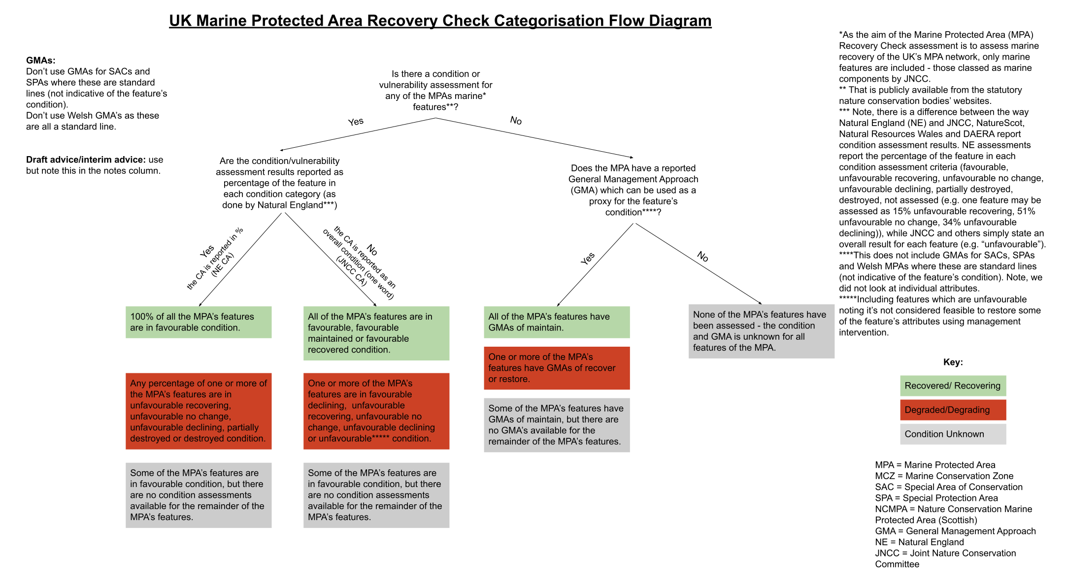
Figure 1: The Wildlife Trusts MPA Recovery Check Assessment Flow Diagram detailing how recovery categories were determined.
Summary Statistics:
To summarise the MPA Recovery Assessment results, we produced a count of the number of MPAs falling under each recovery category, broken down by designation type and country. We did not include Benacre to Easton Bavents Lagoons SAC and Great Yarmouth North Denes SPA in these summary statistics, as these sites have no features which are considered marine components by JNCC.
When it came to counting the number of MPAs falling under each condition category per country, a cross-border MPA that was only partially within the seas of one country (with the rest within the seas of another country), was treated as ‘half’ an MPA. This means that the summary data per country avoided double counting MPAs that span the border between countries.
Assumptions and Limitations
While we endeavoured to find all applicable and up-to-date information on SNCB websites (searching all the reasonably relevant pages (Annex 1)), we note that it is possible some condition/vulnerability assessment results or GMAs are available elsewhere or not publicly available. We noted the date we reviewed the relevant pages (which can be viewed by clicking on each MPA) and will endeavour to update the information and recovery assessment periodically, when we are aware that new information is available.
We included Special Protection Areas (SPAs), Special Areas of Conservation (SACs), Marine Conservation Zones (MCZs) and Nature Conservation Marine Protected Areas (NCMPAs) in our assessment. We did not include Site of Special Scientific Interest (SSSIs) and Ramsar sites but note these may also protect coastal/marine habitats and species. We note that condition assessments of SSSI and/or Ramsar features/units may contain relevant data for MPA features included in this assessment3, however these were not used as a proxy for MPA condition assessments due to the complexity this would add to the assessment. We hope the appropriate SNCBs will use relevant data from SSSI/Ramsar sites to inform overlapping MPA condition assessments, when these are undertaken.
As the aim of the MPA Recovery Check Assessment is to assess recovery of the UK’s MPA network, we only included marine features of SPAs and SACs which are classified as marine components by JNCC. This decision was made as several MPAs included features which may be considered terrestrial (e.g. woodland) or could be considered either terrestrial or marine (e.g. waders and otters). This is particularly true for MPAs in Scotland.
We note that there may be features which could be considered marine features but are not officially classed as marine components by JNCC, and are therefore not included in the assessment. We recognise that NatureScot include all assemblage components (i.e., waterbird assemblage, breeding bird assemblage and seabird assemblage) of MPAs as qualifying features, while Natural England take a different view and do not consider assemblage components as qualifying interest features in their own right (which can lead to differences in the reported features for some MPAs e.g., Solway Firth SPA, The Swale SPA). We followed the lead SNCB’s website, with additional advice from JNCC where the designated features of MPAs were unclear. We have endeavoured to make it clear which features are and are not included in our assessment. Please click on individual MPAs to view details of all the features, including which features are classed as marine components and therefore included in the recovery assessment. We note, if all features were included in our assessment this may have resulted in the different categorisation of the several MPAs.
For SACs and SPAs where seabird assemblages were split into breeding and non-breeding features on the relevant SNCB website for the MPA, but not by JNCC’s marine components spreadsheet, both breeding and non-breeding seabird assemblages were assumed to be classed as marine components.
Due to the layout and lack of detail on SNCB websites, it was often not possible to determine whether the reported condition was determined from a full condition assessment or a vulnerability assessment. Therefore, we are unable to clarify between the two. We did not look at the attributes of features and their related targets as a proxy for condition assessments due to limited resources and the added complexity this would entail.
Where condition/vulnerability assessments were not available, we assumed that the SNCB determined GMAs (often from the factsheet produced when the MPA was designated) are indicative of the condition of these sites. We used this as the best available proxy for feature condition, but acknowledge this may not be accurate for all sites. We did not assume this for Welsh MPAs or sites where the GMAs appeared to be a standard line, as upon review these were deemed not to reflect the condition of the features. We note that individual attribute targets for features may differ from the overall feature GMA.
We included all condition/vulnerability assessments and GMAs in our recovery categorization assessment, no matter the date they were determined or their reported confidence (i.e., old and low confidence data was included). The assessment therefore is based on the most recent available information, which we recognise may be out of date and/or of low confidence, and may not represent the current condition of the site. This is a significant limitation of the MPA Recovery Assessment which we hope will be improved as more condition assessments are undertaken in the future.
Condition/vulnerability assessments were primarily used for our recovery assessment, with GMA’s only acting as a proxy where a condition/vulnerability assessment did not exist. As such, the recovery assessment calculations (which you can see by clicking on each MPA) do not sum the percentage of MPA features with maintain/recover GMAs where condition/vulnerability assessments are available, although they may be detailed in the feature information. Where no condition assessment was available, we added the link to the main page we checked for this information so it’s clear where we looked (you can see this by clicking on individual MPAs).
Where a condition/vulnerability assessment was available that’s more recent than the GMA, we used this. Where both a condition assessment and GMA were available for the same feature and these did not align, we presumed the most recent one was correct and used this for our recovery assessment. Where the condition assessment was marked as “not assessed” for a feature with a more recent date than the GMA from designation, we presume this supersedes the GMA and therefore counted this as unknown.
Where the most up-to-date GMA or condition/vulnerability assessment was available in draft conservation advice documents this was included in our assessment, noting this next to each relevant feature.
Strangford Lough MCZ and Skomer MCZ were considered as “condition unknown” as no features have been designated for these sites.
We note that any condition/vulnerability assessments or GMAs for birds which were carried out before the avian influenza pandemic are unlikely to be representative of the current condition of these features, given the significant impact of this disease on UK seabird and wader populations.
We note that Natural England’s Marine Condition Assessment methodology is currently only applied to ‘marine habitat features’ listed in Annex I of the EC Habitats Directive. These are: coastal lagoons, estuaries, large shallow inlets and bays, mudflats and sandflats not covered by seawater at low tide, reefs, sandbanks which are slightly covered by sea water all the time, and submerged or partially submerged sea caves. Other features (marine species, coastal habitats) are assessed using different methodologies (e.g. SSSI assessments, accessible on DSS on the site detail pages of the respective SSSI), or in some cases by the JNCC (e.g. marine mammals). We did not look at SSSI or JNCC assessments as proxy’s for MPAs.
We note that the assessment methodology is biassed towards MPAs with less features and assessments reported as one whole word condition/vulnerability assessment result (e.g. JNCC’s, NatureScot, NRW and DAERA assessments). As NatureScot considers all components of assemblages as qualifying interest features, Scottish MPAs are more likely to have more features than English sites.
While our assessment classifies the whole-MPA with an overall recovery category, we note that many MPAs are not managed by a whole-site approach. Most MPAs (SPAs, SACs, MCZs and NCMPAs) are designated by a features-based approach where specific habitats or species are designated as features of the MPA. Feature-based MPAs are often only managed and monitored to protect the site's designated features, ie., not the whole site or habitats and species which are not designated. For example, the North Anglesey Marine SAC is designated to protect harbour porpoise but is not designated to protect anything else within the site. The assessment therefore reflects the condition of the MPA’s features, and is not an area-based assessment of the whole-marine environment covered by the MPA. We note habitats and species which are not designated features may or may not be indirectly protected by the MPA.
Recovered/Recovering condition does not indicate that continued/additional management measures are not required. Nor does it indicate this condition is expected to persist in the future, given ever changing and/or unforeseen threats such as climate change and invasive non-native species.
Quality Assurance & Peer-review
Excel was used to check percentage calculations added up to 100% for all 377 UK MPAs.
An independent colleague in The Wildlife Trusts quality checked the categorisation results of a random sample of the results, equating to 10% of all UK MPAs.
Where resources allowed, both the MPA information and the MPA’s overall recovery categorisation was also checked by marine officers in local Wildlife Trusts across the UK.
Where expert knowledge indicated the assessment may not be accurate, the categorization of a few MPAs was altered. Where this has occurred, it is clearly noted and justified. Please click on individual MPAs for specific details.
Terms of Use of the MPA Recovery Check
- The Wildlife Trusts is not liable for any errors or omissions in the information and shall not be liable for any loss, injury or damage of any kind caused by its use. While we endeavour to periodically update the assessment as necessary, The Wildlife Trusts do not guarantee the continued supply of information. It is your responsibility to ensure the information is fit for the intended purpose.
- The data the assessment is based on is derived from a synthesis and review of evidence publicly available on SNCB websites (references available by clicking on individual MPAs). This information is likely to change.
- The assessment reflects the views at the time of assessment (noted for each MPA as the date the site condition assessment was reviewed) based on the best available evidence to our knowledge. As a result, any additional information or clarification of existing evidence may result in future updates to the assessment.
- All persons referring to or using the MPA Recovery Check results must reference this with “The Wildlife Trusts ([date of last update - as below]), MPA Recovery Check Assessment. Available at: https://mpa-reality-check.org/.”
- This assessment was last updated 6th August 2025. For a full list of previous updates, please see Table 2.
We would love to hear your feedback on the MPA Recovery Assessment so we can ensure it is as useful as possible. If you have any feedback, are aware of any new information we haven’t included or would like further information about the assessment, please contact [email protected].
Table 2:
| MPA Recovery Check Version | Date Updated | Updates |
| 1.0 | 06-08-2025 | First published 23/10/2025 |
Annex 1
The main websites used to find MPA information and condition/vulnerability assessments and GMAs:
https://designatedsites.naturalengland.org.uk/
http://publications.naturalengland.org.uk/category/3229185
http://publications.naturalengland.org.uk/category/6490068894089216
https://www.gov.uk/government/collections/conservation-advice-packages-for-marine-protected-areas
https://naturalresources.wales/
https://sitelink.nature.scot/home
https://www.daera-ni.gov.uk/protected-areas
https://www.daera-ni.gov.uk/publications/202324-summary-feature-condition-status
https://gis.daera-ni.gov.uk/arcgis/apps/webappviewer/index.html?id=e44a8e27333241bfa2faf4a387fd99d7
Annex 2
For Natural England condition assessments, where each feature's condition assessment is split into percentages, this was calculated by adding the percentage of each feature in these categories.
For example, an MPA has 2 features which are marine components, with feature condition assessments reported as 20% favourable and 80% unfavourable for the first feature and 50% favourable and 50% unfavourable for the second feature. Each feature contributes towards 50% of the total MPA condition, 100/2 = 50.
We then calculated the percentages of each feature that contributes towards each recovery category: recovered/recovering, degraded/degrading or unknown from the condition assessments. I.e, for the first feature, 20% is in favourable condition (20%) and will therefore contribute towards 10% recovered/recovering ((50/100)x20=10%) of the total MPA condition. 80% of the first feature is in unfavourable condition which contributes 40%, (50/100)x80 = 40%), of the total MPA condition. The second feature contributes 25% favourable to the total MPA condition, ((50/100)X 50 = 25%), and 25% unfavourable, ((50/100)X 50 = 25%).
Overall the MPA condition is 35% (10%+25%) favourable and 65% (40 %+ 25%) unfavourable. Following our standardised methodology (see the flow diagram above) this gives the whole MPA a recovery category of “Degraded/Degrading” following the 100% Rule.
Table 3, shows these calculations broken down, if read left to right.
Table 3:
|
Feature |
Natural England Condition Assessment |
Percentage the Feature Contributes to the Whole MPA |
Percentage of the feature in each recovery category |
Percentage of the MPA in each recovery category from this feature |
Total MPA in each recovery category |
Overall MPA Recovery Category |
|
Feature 1 |
20% favourable
80% unfavourable |
50%
(As the MPA has two features) |
20% recovered/recovering (20% in favourable condition)
80% degraded/degrading (80% in unfavourable condition)
|
(50/100) x 20 = 10% recovered/recovering
(50/100) x 80 = 40% degraded/degrading |
(10 + 25) = 35% recovered/recovering
(40 + 25) = 65 degraded/degrading |
100% Rule = Degraded/Degrading |
|
Feature 2 |
50% favourable
50% unfavourable |
50%
(As the MPA has two features) |
50% recovered/recovering
50% degraded/degrading |
(50/100) x 50 = 25% recovered/recovering
(50/100) x 50 = 25% degraded/degrading |
1Natural England, JNCC, Natural Resources Wales, NatureScot and DAERA.
2Outlined in the relevant spreadsheets for SPAs and SACs. Each following JNCC’s methodology,
available here.
3We note the following statement from Natural England (on all the marine condition pages available through the Designated Sites View website): “Please note, Natural England’s Marine Condition
Assessment methodology is currently only applied to ‘marine habitat features’ listed in Annex I of the EC Habitats Directive. These are: coastal lagoons, estuaries, large shallow inlets and bays, mudflats and sandflats not covered by seawater at low tide, reefs, sandbanks which are slightly covered by sea water all the time, and submerged or partially submerged sea caves. Other features (marine species, coastal habitats) are assessed using different methodologies (e.g. SSSI assessments, accessible on DSS on the site detail pages of the respective SSSI), or in some cases by the JNCC (e.g. marine mammals).”